The Atlantic hurricane season runs from 1st June to 30th November. The 2022 hurricane season aligned with NOAA’s projected expectations for named storms and hurricanes, as stated in both their initial and revised forecasts. Throughout the season, there were a total of 14 named storms, 8 of which developed into hurricanes, and 2 of those further intensified into major hurricanes.
Despite a decrease in the number of major hurricanes in 2022 compared to previous years, the ones that did reach land made significant impact. Hurricane Ian, a Category 4 storm, made its initial landfall in Cayo Costa, Florida, with maximum sustained winds of 150 mph, it is tied for the fifth-strongest hurricane ever recorded to hit the United States.
Another notable hurricane, Fiona, originated as a tropical wave originating from West Africa. It developed into a tropical depression east of the Leeward Islands and eventually intensified into a destructive Category 4 Atlantic hurricane. Fiona holds the record as the costliest and most intense tropical or post-tropical cyclone to strike Canada.

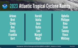
For the 2023 season NOAA has predicted 12 to 17 total named storms (winds of 39 mph or higher), of which, 5 to 9 could potentially become hurricanes (winds of 74 mph or higher), including 1 to 4 major hurricanes (category 3, 4 or 5; with winds of 111 mph or higher). There is a strong likelihood of El Nino developing this summer, following consecutive La Nina seasons, which could supress this year’s activity. Winds spurred on by El Nino, a natural climate pattern marked by warmer than average Pacific Ocean water, tend to prevent Atlantic storms from developing.
In April, Colorado State University (CSU) released a similar prediction, forecasting 13 named storms, 6 hurricanes and 2 major hurricanes. The CSU cited the likely development of EL Nino as a contributing factor to the slight below average forecast.
Increased investment from the Commerce Department and NOAA’s critical investments in scientific and technological advancements in hurricane modelling has resulted in NOAA being able to deliver more accurate forecasts. NOAA will be launching a series of upgrades and improvements including expanding the capacity of its operation supercomputing system by 20%.
NOAA is also continuing to improve new and current observing systems critical in understanding and forecasting hurricanes including launching new small aircraft drone systems, the deployment of additional Saildrones and underwater gliders, and WindBorne global sounding balloons. These modern technologies will help to deepen collective knowledge of hurricanes, complete critical data gaps and improve hurricane forecast accuracy.
To enable our insurance clients to respond as quickly as possible to any damaging storm event our on-demand CAT response service, (RE)ACT, is available to track and respond to any storm 24/7/365. Using AI-based analytics which draw on imagery captured from over 600 satellites and a unique network of drone and aerial operators on every continent (RE)ACT provides rapid and accurate per-property damage estimation within hours of the impact of a storm event.
Visit the (RE)ACT product page for more information or to request a demo to ensure you are fully prepared for the upcoming season.
Stay informed about active storms, their trajectory, and potential impact through our regular RE(ACT) watch roundups on LinkedIn and Twitter. Follow us to keep track of the season’s progress.