Our latest service is underpinned by a unique data processing methodology known as APSIS (Advanced Pixel System using ISBAS). This innovative algorithm was developed by Terra Motion Limited and the University of Nottingham as a disruptive solution to enable ground movement measurements over all surface types, including urban areas and both natural and vegetated terrain.
In the last few years, the technique has been constantly reviewed, tested, validated, and updated to increase confidence, resolution, accuracy and to support new applications. Taking full advantage of the extensive archives of satellite radar data such as Sentinel-1, MotionMonitor can provide the most complete and up-to-date analysis of ground movements globally, including of key locations such as mine tailings dams and beaches and the surrounding slopes.
APSIS Overview
APSIS is the only InSAR-based technique that is optimised to provide a near-complete density and spatial distribution of ground movement measurements across any site, in vegetated and non-vegetated areas alike. APSIS can retrieve these measurements for targets that vary in intensity and quality throughout the period of observation – as a result, the density of survey pixels returned is higher and their distribution is not limited to urban centres or “hard targets” such as rods, which is the case with all other InSAR-based survey methods.
The APSIS technique has been successfully publicly-validated against ground observations in both urban and rural terrain, and wide-scale mosaics of millimetric-level ground surface movement may be formed from individual surveys. National mosaics of the UK, Netherlands and Germany, generated using APSIS, are now available. These results, and others, have demonstrated that APSIS can be used with confidence over locations where traditional ground-based survey measurements are not available and without recourse to the use of ground infrastructure, such as corner reflectors.
InSAR Overview
Interferometric Synthetic Aperture Radar (InSAR) is a technique used for mapping ground deformation using radar images of the Earth’s surface that are collected from orbiting satellites. It works by taking pairs of images and identifying the subtle changes between them, which can be resolved to within millimetric accuracies. Data from observations made over several years can then be used to form some permutation and combination of pairs, and by integration make a very precise map of the subtle changes of land surface over that period.
This often reveals the slow settlement or rise of features across a landscape that are undetectable by other means, but also may identify the subtle changes that are the precursor of a catastrophe, such as the collapse of a cliff face, a dam, a road cutting or a railway embankment for example.
InSAR is not a new technology and there are many different methods on offer, each with different advantages and disadvantages. APSIS, however, is the only InSAR-based technique that provides a comprehensive wall-to-wall survey across the landscape, using all types of data, from X- C- and L-band satellites, that does not rely on the use of corner reflectors or other ground-based infrastructure to densify the measurements.
Benefits of APSIS vs. other InSAR
- Near-complete coverage of measurements over natural and vegetated terrain, as well as urban areas, using any current or historical source of satellite InSAR data.
- A truly remote monitoring system that does not require ground infrastructure, compared to many other InSAR methods that require artificial corner reflectors to be placed across a site.
- High-level precision and detail allows motion to be assessed and monitored on a regular basis, supporting asset management and risk assessment. Results can then be easily integrated with existing ground data.
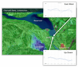
- Comprehensive, wall-to-wall coverage means the entire spatial extent, context and dynamics of any motion can be visualised. If appropriate satellite data is available, stereo analysis can also be performed to provide 2D motion vectors, Up-Down and East-West.
- High-density measurements mean a more complete picture of the motion. This helps to identify the full extent of any hazards, determine what key infrastructure is likely to be affected, highlight the cause of the motion and inform potential mitigation actions.

- High-density maps of surface motion can be used to monitor a full range of phenomena; from the collapse and erosion of soils and earthworks, to the subsidence and heave caused by the removal or storage of fluids deep underground.
- Processing on a pixel-basis rather than a point means that results are most naturally suited to raster format.
- APSIS utilises historical data archives, anywhere in the world with no intervention required on the ground.
The Award-winning APSIS method is uniquely able to bring near complete coverage over areas of natural and vegetated terrain. This is traditionally where conventional InSAR methods struggle to make any observations without corner reflectors, and the underlying solution is being developed with increased levels of automation and scalability through migration to cloud processing architectures.
Related development
Building on our experience with APSIS and the value of full-coverage InSAR monitoring, learn more about our recent launch of MotionMonitor for more information. A tailored solution designed specifically for the proactive monitoring of tailings storage facilities. This new capability combines multi-sensor ground movement data with expert analysis to support improved safety and environmental resilience.
Visit the MotionMonitor product page for more information or to request a product demonstration.