This case study will include 2 example applications of high-resolution mapping, covering the analysis of glaciers around Mount Everest and urban disaster risk reduction in cities such as Kathmandu (Nepal).
Glaciers are disappearing across much the Himalaya, which has profound environmental and social implications. Over a billion people depend on downstream water availability from the Himalaya, including for food production and energy generation. 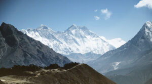
Climate change is increasingly affecting the magnitude and seasonality of these water flows, which is threatening livelihoods and socio-economic development. Glacier melt is a hallmark of climate change and is long studied in the Everest region of Nepal, where glaciers hundreds of metres thick lock away vast quantities of water. Much of the glacier ice is covered by a veneer of rock and sediment, which protects it from solar radiation on the one hand, but promotes the accumulation of meltwater on the surface on the other. Water bodies hundreds of metres across and tens of metres deep are now forming on Khumbu Glacier, which is home to Everest basecamp in Nepal. These supraglacial ponds are hot spots of melt and elsewhere have coalesced into large glacial lakes where they occupy the space left by former glaciers.
WATER BODIES HUNDREDS OF METRES ACROSS AND TENS OF METRES DEEP ARE NOW FORMING ON KHUMBU GLACIER…
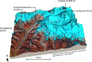
Elevation models generated using high resolution satellite imagery are used to quantify rates of glacier thinning and measure the development of supraglacial pond and lakes. A broad range of satellite and field data was sourced and used in the work, including Pleiades imagery supplied through an agreement with the European Space Agency. The imagery was processed with IMAGINE Photogrammetry using high accuracy ground control points collected in the field. The research has demonstrated that Everest’s glaciers are stagnating and thinning, which is leading to large ponds forming on their surface. Glacier decline is causing these high mountain environments and downstream areas to become increasingly hazardous, with events such as landslides and floods projected to increase.
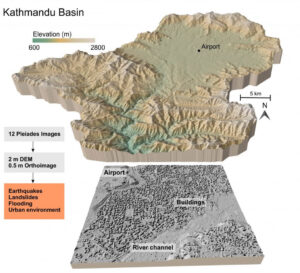 Haphazard urbanisation is a global trend that is often associated with increased disaster risk, especially for society’s most vulnerable. Reducing disaster risk for ‘Tomorrow’s Cities’ is the aim of the Urban Disaster Risk Hub, which uses interdisciplinary research embedded within local communities and organisations to develop disaster risk resilience. Earth observation data play key role in the hub, helping to assess multi-hazard process chains and the structure of the built environment, whilst also providing city-wide perspectives for local engagement activities and coproduction of knowledge. IMAGINE Photogrammetry was used to generate 2m resolution DEMs of the Kathmandu Basin using tri-stereo Pleiades satellite imagery acquired through the Committee of Earth Observing Satellites (CEOS) seismic hazards demonstrator project. The elevation models and orthoimagery serve a broad range of applications including modelling floods and earthquakes. The DEMs and ortho imagery are also used to assess the structure of the built environment, including building heights and distribution of greenspace around the city. It is only with such high-resolution data that the impact of natural hazard events can be assessed at scales spanning individual livelihoods to whole cities, with greatly reduced uncertainties compared to using coarser global DEMs.