With the world facing unprecedented environmental challenges, renewable energy has become essential to combat climate change. From rising sea levels to more frequent extreme weather events, the impact of fossil fuels has become increasingly evident. Solar power is a leading solution, providing an effective way to reduce carbon emissions. Yet, the transition to solar energy is complex, as every property has unique characteristics that affect solar suitability. Geospatial Insight’s LOCATE SOLAR addresses this need, delivering detailed, data-driven analyses on a national scale to help stakeholders make informed decisions about solar energy investments.
Context: The Urgent Need for Renewable Energy
The escalating effects of climate change are felt globally, urging governments and organisations to commit to more ambitious carbon reduction targets. In the European Union, for instance, all new residential buildings will require solar panels by 2030, with the UK setting similar standards by 2025. Solar power is a central element in these initiatives, but the success of such projects depends on accurately assessing whether a specific property can effectively harness solar energy.
For homeowners and businesses alike, solar power offers environmental and financial benefits, but these are only achievable if each installation is optimised for its location. Key factors like roof angle, size, and shade from nearby features impact efficiency. Geospatial Insight’s LOCATE SOLAR was developed to tackle this challenge, offering a solution that makes solar suitability analyses scalable and precise.
The Challenge: Accurate and Scalable Solar Suitability Analysis
Evaluating a property’s solar potential requires a deep understanding of its unique physical characteristics. Previous methods for analysing solar suitability were often labour-intensive and limited in scale, making it challenging to keep up with the rapidly evolving solar industry. For example, the most common panel size in 2020 was 250W, but this has since increased to 350-450W, significantly boosting efficiency. Recognising the need for up-to-date, accurate insights, Geospatial Insight created LOCATE SOLAR, a tool designed to streamline solar analysis on a large scale.
Solution: Leveraging Geospatial Data for Precise Analysis
LOCATE SOLAR combines open-source geospatial data, such as LiDAR (Light Detection and Ranging) and detailed building footprints from Ordnance Survey, to create a highly accurate, 3D solar suitability model. LiDAR data provides a detailed digital surface model (DSM) of the terrain, capturing above-ground features like buildings and trees. Using this, LOCATE SOLAR creates realistic 3D representations of individual properties across the UK.
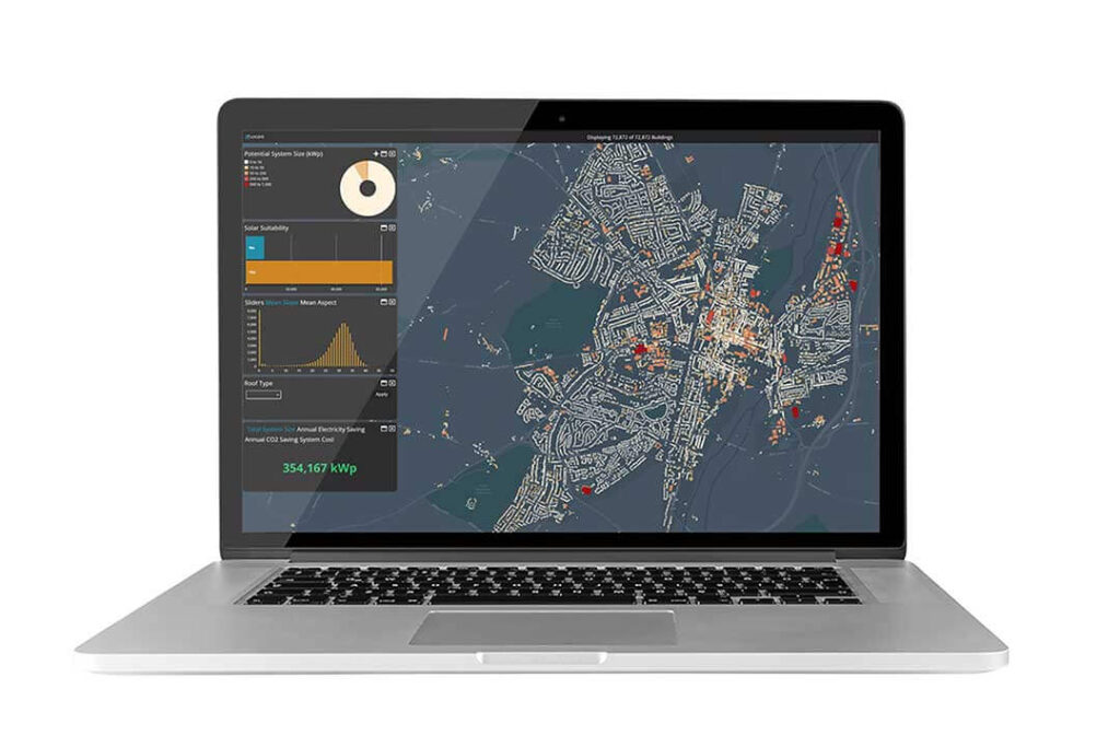
This advanced tool analyses each property’s roof characteristics – including pitch, orientation, and usable area – to identify roofs suitable for solar installations. With automation and high-resolution data, LOCATE SOLAR makes solar analysis fast, efficient, and scalable. Once a roof’s suitability is determined, further calculations estimate solar irradiation, a key factor in predicting the financial and environmental benefits of solar panels.
Key Features of LOCATE SOLAR
LOCATE SOLAR delivers several essential insights that enable stakeholders to make informed decisions about solar investments. Key features include:
Power Output Assessment:
The tool reflects current solar technology, including 450W panels, allowing accurate estimates for potential energy production, which is crucial for properties with limited roof space.
Self-Consumption vs. Export Calculations:
LOCATE SOLAR calculates the percentage of energy used on-site (self-consumption) versus energy returned to the grid (export). This factor is vital in financial projections, as higher self-consumption usually results in greater cost savings and a faster return on investment.
Tailored Cost Estimates:
Installation costs are adjusted based on property type (residential or commercial), providing realistic financial projections that reflect real-world price ranges.
Payback Period and Savings Projections:
The tool estimates the payback period, which indicates how long it would take for a solar installation to pay for itself. This feature is crucial for helping users assess the financial viability of installing solar panels.
These analytical capabilities make LOCATE SOLAR a comprehensive solution for evaluating both the technical feasibility and the financial benefits of solar energy installations.

Impact and Outcomes
Geospatial Insight’s LOCATE SOLAR has redefined solar suitability assessment, enabling scalable, data-driven decisions that empower stakeholders and redefine renewable energy standards. The tool empowers stakeholders, including property owners, energy providers, and policymakers, to make data-driven decisions about solar energy investments. By offering reliable data on a property’s solar potential, LOCATE SOLAR supports the UK’s renewable energy goals and helps reduce the financial and logistical barriers to solar adoption.
The impact of LOCATE SOLAR extends beyond financial savings. By facilitating widespread solar adoption, the tool supports the broader fight against climate change, contributing to the UK’s efforts to lower carbon emissions and transition towards a greener energy grid. As the effects of climate change become increasingly urgent, tools like LOCATE SOLAR offer an invaluable resource, combining advanced geospatial analysis with practical, actionable insights to support a sustainable future.
Real World Success Stories
LOCATE SOLAR’s capabilities have already demonstrated tangible benefits in real-world applications. For instance, the London Borough of Lambeth Council reported that using LOCATE SOLAR saved them ‘months’ of roof survey time compared to traditional, manual methods. This efficiency not only accelerated their renewable energy projects but also reduced costs associated with labour-intensive surveys.
Additionally, through energy consultants PowerCircle Projects, Geospatial Insight collaborated with Westminster City Council to assess solar potential for 4,000 social housing properties. The goal was to identify opportunities to reduce energy costs and help lift residents out of fuel poverty.
Conclusion: Driving Renewable Energy Forward with Technology
LOCATE SOLAR demonstrates the potential of technology to advance renewable energy initiatives. By harnessing the power of detailed geospatial data, Geospatial Insight has made large-scale, accurate solar suitability analysis achievable and accessible. As demand for sustainable energy solutions grows, LOCATE SOLAR stands as an innovative example of how data-driven insights can accelerate the transition to renewable energy and contribute to a cleaner, more resilient future.
