When one of the bank’s farming customers applies for a loan, a range of potential risks must be checked to validate their credit worthiness. This process is underpinned by analysing numerous variables affecting crop sites that are geographically dispersed, differ in size, and are subject to specific risks that can impact cash flow – thereby influencing a yes or no credit lending decision. These variables include risk factors such as topography, soil fertility, hours of sunlight, flood risk, crop extent and density, growth and productivity over time, crop health, land displacement risk, climate variation, and plantation proximity to transport routes.
The banking group was interested in exploring the potential of remotely sensed data to complement their credit scoring methodology, currently a time consuming and manual process heavily relying on paper records from archives and/or customer supplied information, which may not always be accurate or complete. Derived intelligence from satellite data can offer a consistent approach across all geographies giving the banking group a more reliable and independent data source from which they can determine risk insights at seasonal intervals.
“DERIVED INTELLIGENCE FROM SATELLITE DATA CAN OFFER A CONSISTENT APPROACH ACROSS ALL GEOGRAPHIES GIVING A MORE RELIABLE AND INDEPENDANT DATA SOURCE TO DETERMINE RISK INSIGHTS AT SEASONAL INTERVALS.”
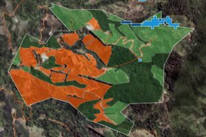 To undertake crop identification and change detection, data collected over a five-year time period was used. Over lowland, less cloud covered areas there was plentiful high spatial resolution data available for analysis. For this area Worldview-3 data was utilised. Over the hilly, more cloudy areas there was less choice of data. Fortunately, Planet 3-metre data provided sufficient coverage for the analysis. The remotely sensed data was analysed using a combination of machine learning and visual interpretation techniques in ERDAS IMAGINE. Crop identification between coffee and avocado was challenging using the 3-metre data but there were sufficient textural differences to enable separation of classes.
With more training areas and sufficiently accurate ground truthing, it is anticipated that better results will be achieved using the new Semantic Segmentation process available in v2020 Update 3 of ERDAS IMAGINE.
The analysis of satellite imagery illustrated the power of remote sensing data to enhance the bank’s knowledge of the specified crops and provide further insight to assist in their credit lending decision making process. As a result of the study we were able to provide the following data to the bank:
- An increase in avocado crop extent by 74%
- A consistent extent of oil palm and coffee crops
- A 28% decrease in general forest area compared to a 26% increase in cultivated land area
- Identification of areas exhibiting land displacement, suggesting further investigation is required
- Flood risk analysis for both river and surface water
Satellite derived visual intelligence is an efficient way for banking and investment professionals to improve their understanding of risk, facilitate improved credit scoring capabilities, and strengthen client relationships – especially where customer service and risk management are important components of the lending process.
For more information about how we could assist your organisation, contact us at [email protected].