Ask a Question

Catastrophe Response

In the past decade, extreme weather events have increased in frequency and severity due to climate change – globally insured losses reached $105 billion in 2023. With NatCat (Natural Catastrophe) incidents such as wildfires, hailstorms, and tropical cyclones becoming more frequent, insurers and governments must prioritise understanding their exposure to improve resource and capital allocation.

A logo of (RE)ACT with a green globe for an icon to represent catastrophe response.

Solution


Our NatCat response service, (RE)ACT, provides rapid post-event exposure analysis for insurers, governments and NGO’s. Utilising near real-time data, machine learning, and expert image analysis, we can help build a holistic view of an event’s impact on exposures and population.

Leveraging unparalleled expertise in NatCat response planning and mission control, our team of specialists collaborate closely with our clients to deliver responses that meet their specific needs.

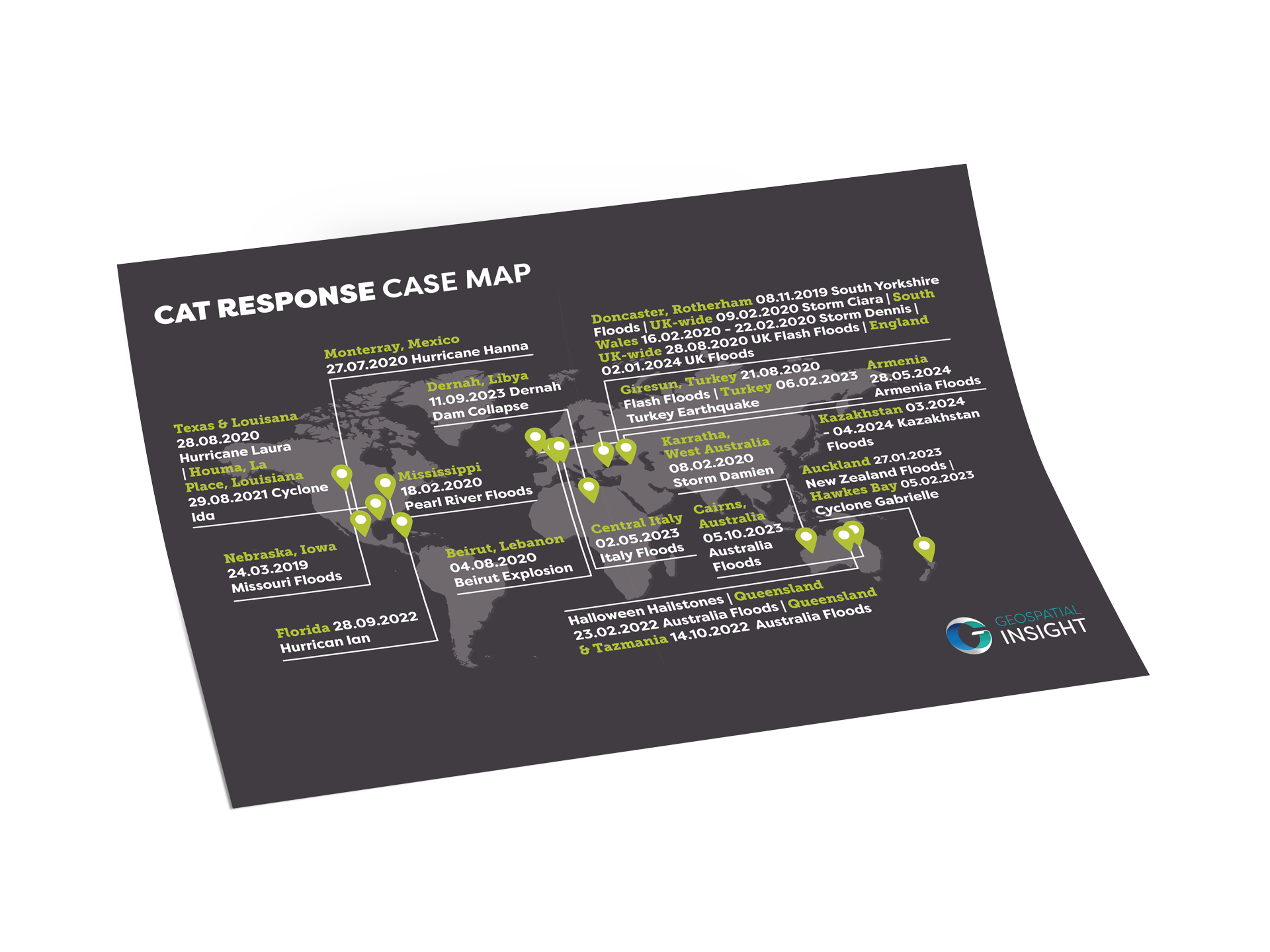
With access to over 700 satellites, a global drone network, and aerial survey partners on every continent, and with experience gathered from responding to 100+ catastrophic events in recent years, (RE)ACT delivers rapid post-event exposure analysis for insurers, governments and NGO’s worldwide.

Ready to get in touch?

A map of the world with different dates to represent the catastrophe responses Geospatial Insight has analysed.

Benefits

An icon of a piece of paper in a cog to represent enhanced claims processing.

Enhanced Claims Processing

Expedite claim settlements by providing an initial and accurate First Notice of Loss (FNOL)

Icon of a tick inside a cog to represent enhanced claims verification.

Enhanced Claims Verification

Streamline claims verification with precise geospatial data to reduce fraud and expedite legitimate claims

A icon of a hand holding a pound coin to represent funding.

Streamlined Response

Lower operational costs by conducting remote assessments, reducing need for physical intervention

An icon of a piece of paper with a list and ticks next to them to represent reputation enhancements.

Reputation Enhancement

Enhance credibility and reduce settlement costs by promptly resolving claims

Download

Download the (RE)ACT brochure

DOWNLOAD
A mock up of a brochure for (RE)ACT showcasing our catastrophe response abilities.

Case Studies

Mid-West USA floods

Following the destruction brought by the recent extensive flooding in Nebraska and Iowa in the…

FIND OUT MORE

Storm Eva – UK floods

Between Storms Desmond, Eva and Frank, the month of December 2015 was Britain’s wettest in…

FIND OUT MORE

Hurricanes Harvey and Irma

Hurricane Harvey had a catastrophic effect on Houston and its surrounds, displacing approximately 1 million…

FIND OUT MORE

Features

A icon of a picture of a house on a piece of paper to represent rapid loss estiamtion.

Rapid Loss Estimation

Quickly assess and scope losses within hours of an event

Icon of a piece of paper with lines behind it to represent prompt damage report.

Prompt Damage Documentation

Rapidly deliver property damage intelligence

Icon of a piece of paper with a damaged house to represent historical damage evaluation.

Historical Damage Evaluation

Conduct retrospective assessments of damage for past events using global image archives

A icon of a house with a medical cross inside to represent post damage recovery.

Post-Disaster Recovery

Inform and assist humanitarian aid response and community rebuilding

Check out the Latest Insights and Updates from the Geospatial Insight Team

Learn More

Request a demo

Fill The Form Out Below And One Of Our Sales People Will Be In Touch Shortly

Interested In Buying Our Products?

Fill The Form Out Below And One Of Our Sales People Will Be In Touch Shortly