The first thing that is noticeable when using IMAGINE 2022 is the image display now defaults to Image Chain. Image Chains have been available within IMAGINE for many releases, but with this release almost all the functionality that was previously dispersed across the Multispectral/Panchromatic/Thematic tabs is now consolidated under the Image Chain tab. The primary benefit is the ease of switching between Image Chains. Using the legacy raster render, changing an image from Grey Scale to Pseudo Colour would involve removing the image from the View and starting again. This used to happen all the time with data such as an NDVI, which is generally produced as athematic data and so defaulted to a Grey Scale display, when the user wanted to apply a colour ramp to the data it would have to be redisplayed as Pseudo Colour.
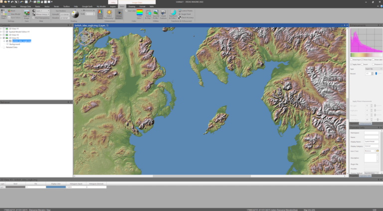
With Image Chains, you simply select the Image Chain you wish to swap to, and it will automatically update. Therefore, if an athematic NDVI defaults to the Panchromatic chain, it can be easily switched to Pseudocolour rather than using a colour ramp. Another benefit included within Image Chains is a more comprehensive relief display for elevation data.
The next noticeable feature when using a high-resolution monitor is that the interface has been overhauled to support Windows scaling value. This means that the software will scale the user interface elements while making full use of the display area.
As always with ERDAS IMAGINE updates, it’s the Spatial Modeler that takes up the most space in the Release Guide with twenty completely new operators and over a dozen updated operators, giving additional functionality such as automatic ground control point creation, photogrammetric operations and a streamlined way to create deep learning training chips. There are also nice adjustments to the interface that help improve the already excellent user experience.
One thing I have been asked many times over the years is, ‘can the model be exported to Python?’. I can now answer “yes!”. The exported Python script can then be used as-is or modified with other Python capabilities.
“ONE THING I HAVE BEEN ASKED MANY TIMES OVER THE YEARS IS ‘CAN THE MODEL BE EXPORTED TO PYTHON?’. I CAN NOW ANSWER YES!”
IMAGINE has always supported a wealth of data formats, this release sees the additional support of USGS Landsat Collection 2, and Landsat 9 data will be readable as well when it comes online. SRTM HGT is readable in Spatial Modeler and deployable via the Image Chain. DIMAP v2 now opens and displays more efficiently.
SAR functionality has been enhanced with Beta 0 and Sigma 0 radiometric conversions now supported for most radar sensors. Capella and ICEYE files will open correctly and show Magnitude and Phase. Finally, Sentinel-1 GRD files will now use the SAR sensor model for more accurate georeferencing.
As always, more information about the new technology can be found under the online Hexagon Geospatial help. Discussions about IMAGINE and example Spatial Models can be found on the all-new look Hexagon Geospatial Community. These are all definitely worth a look to gain tips and tricks to enhance your workflows.
This new release also includes lots of behind-the-scenes enhancements and resolves a number of bugs. We urge all users to update to this version as soon as possible in order to take advantage of the new technology and stability features provided in this update.
If you would like further information about these new features or to arrange a technical call with our team, please contact us at [email protected]