In this devastating situation, our client’s top priority was to access detailed information about damage to specific properties so that prompt loss estimations and claims assistance could be initiated.
Our methodical and flexible approach to operational logistics delivered these insights in record time. Each island necessitated a unique operational plan, and we assessed local resources, identified challenges and deployed or regional partner networks accordingly. For example, because Dominica could not be accessed, our team leveraged high-resolution satellite data to support our analyses. In cases where access to local airspace was permitted, we conducted boat-based drone flyovers to collect required information.
As a result, Geospatial Insight flexibly provided our clients with near real-time access to critical information in the aftermath of the storm. In fact, in some case, we had already concluded operations and property-level assessments weeks prior to the arrival of the first human assessors.
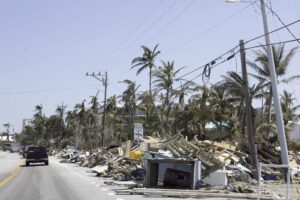
“I’ve looked at a lot of imagery over the last 30 years, and I’ve never seen anything like this.”
Dave Fox, CEO
CAT events are not just extreme in the moment: the aftermath is often rife with logistical challenges and dangers. Our significant operational expertise give Geospatial Insight a significant advantage in overcoming these difficulties and facilitating rapid response, improved service, and a better business model for our clients.